Real-Time Mapping of the Invisible Atmosphere
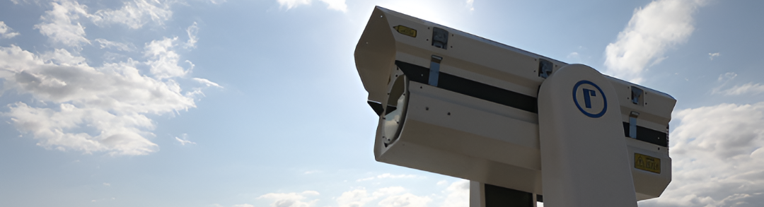
Light Detection and Ranging (LiDAR) represents the frontier of atmospheric profiling technologies. Partnering with world-class technologies from Raymetrics, SIBAKOM provides advanced 3D scanning solutions to track invisible atmospheric hazards in real-time.

Redefining Atmospheric Intelligence
Traditional point sensors only measure pollution at the surface level, leaving a massive blind spot regarding the air above us. SIBAKOM’s 3D Scanning LiDAR systems completely rewrite the rules by actively mapping the entire vertical and horizontal distribution of particulate matter and aerosols over cities and industrial complexes.
Built upon Raymetrics’ premier PMeye platform, this cutting-edge technology uses a unique processing architecture to transform raw laser signals into precise, absolute particulate matter concentrations. Designed for completely automated, unattended operation, it serves as an indispensable tool for heavy industry compliance, aviation safety, and public health management across the nation.
Powerful Core Capabilities
1. Advanced 360° Scanning & Profiling
- Full Spherical Coverage: The system executes continuous horizontal scans up to 360° and vertical zenith scans ranging from -6° to 90°.
- High Spatial Precision: It captures environmental data across long distances with a sharp spatial resolution of 3.75 meters.
- Sectoral Emission Monitoring: It can be configured to perform highly localized sector scans to isolate, track, and quantify emissions from specific plant processes.
2. Unmatched Optical Hardware & Safety
- Eye-Safe Laser Technology: The platform utilizes an eye-safe UV scanning depolarization laser emitting at a wavelength of 355 nm.
- Volumetric Pulse Rate: Operating with an energy of 30mJ per pulse and a repetition rate of 20 Hz, it provides a dense stream of continuous data.
- Dual-Channel Detection: Equipped with a 200mm telescope, it measures both 355p and 355s detection wavelengths to evaluate complex aerosol optical properties.
3. Automated Intelligence & Quality Assurance
- Global Standards Compliance: Our systems strictly adhere to international EARLINET/ACTRIS Quality Assurance procedures.
- Continuous 24/7 Operation: The entire infrastructure is ruggedized and engineered for 24/7 unattended, autonomous field operation.
- Automated Data Processing: An intelligent chain of internal processors automatically converts raw data into high-level surface plots and graphs without requiring manual user input, saving all files in the standard NetCDF4 format.
Premium Applications: Protecting Industries & Communities
Volcanic Ash Tracking & Aviation Safety
Indonesia sits directly on the volatile Ring of Fire, where aviation safety hinges on immediate, precise volcanic ash tracking. Our advanced depolarization LiDAR networks seamlessly differentiate between harmless water clouds and abrasive silicate ash particles. The system instantly measures plume altitude and optical depth while calculating mass concentrations, allowing authorities to confidently define no-fly zones and protect millions of passengers.
Urban Air Quality Profiling & Public Awareness
We empower municipalities to safeguard public health by actively tracking PM2.5 and PM10 particulate matter in full 3D. By accurately monitoring the Planetary Boundary Layer (PBL) height and identifying atmospheric inversion layers, our LiDAR technology maps exact pollution distributions and specific emission sources. This provides an invaluable early warning system for transboundary haze events, keeping the public informed and safe.
Industrial Emission Remote Sensing
For heavy industrial operations, such as steel factories, refineries, and manufacturing plants, our platform serves as the ultimate environmental compliance asset. Extensively validated alongside in-situ PM counters, the scanning LiDAR delivers highly accurate estimations of PM concentrations across multiple plant locations from distances up to a kilometer away. It provides corporate operators with clear, high-correlation data to verify environmental safety and manage plant emissions dynamically.
As a trusted System Integrator for Meteorological Solutions, SIBAKOM delivers precision meteorological, maritime, and infrastructural technology across Indonesia. By bridging Raymetrics' world-class LiDAR innovations with our localized system integration expertise, we offer an elite, hyper-accurate layer of atmospheric protection for our industries and broader society.
Track the Invisible. Protect Your Operations. Secure the Future with SIBAKOM. Contact our corporate headquarters in Jakarta today to explore our automated 3D LiDAR monitoring solutions.
.png)